
WEATHER STATEMENT
ENVIRONMENT CANADA
6:51 p.m. update
-
Little Abitibi - Kesagami Lake
-
Timmins - Cochrane - Iroquois Falls
Severe thunderstorm conditions possible - early evening to evening.
Conditions are favourable for the development of severe thunderstorms that may be capable of producing damaging wind gusts and large hail early this evening. There is also a risk of a tornado.
Large hail can damage property and cause injury. Strong wind gusts can toss loose objects, damage weak buildings, break branches off trees and overturn large vehicles. Remember, severe thunderstorms can produce tornadoes. In Canada, lightning kills up to 10 people every year. Remember, when thunder roars, go indoors.
Emergency Management Ontario recommends that you take cover immediately, if threatening weather approaches.
Environment Canada meteorologists will update alerts as required, so stay tuned to your local media or Weatheradio. Email reports of severe weather to [email protected] or tweet with the hashtag #ONStorm.
For more information:
http://www.emergencymanagementontario.ca/english/beprepared/beprepared.html.
6 p.m. update
-
Timmins - Cochrane - Iroquois Falls
Updated or ended by 6:29 p.m. EDT.
At 5:40 PM EDT, a thunderstorm well east of Timmins is showing signs of rotation based on radar.
A tornado is possible from this thunderstorm. This thunderstorm is moving towards the east.
This is a dangerous and potentially life-threatening situation.
Take cover immediately, if threatening weather approaches.
Go indoors to a room on the lowest floor, away from outside walls and windows, such as a basement, bathroom, stairwell or interior closet.
Leave mobile homes, vehicles, tents, trailers and other temporary or free-standing shelter, and move to a strong building if you can. As a last resort, lie in a low spot and protect your head from flying debris.
In Canada, lightning kills up to 10 people every year.
Remember, when thunder roars, go indoors.
Emergency Management Ontario recommends that you take cover immediately, if threatening weather approaches.
Environment Canada meteorologists will update alerts as required, so stay tuned to your local media or Weatheradio. Email reports of severe weather to [email protected] or tweet with the hashtag #ONStorm.
For more information:
http://www.emergencymanagementontario.ca/english/beprepared/beprepared.html.
5:17 p.m. update
-
Timmins - Cochrane - Iroquois Falls
Updated or ended by 5:59 p.m. EDT.
At 5 PM EDT, a thunderstorm east of Timmins is showing signs of rotation based on radar.
A tornado is possible from this thunderstorm.
This thunderstorm is moving towards the east.
This is a dangerous and potentially life-threatening situation.
Take cover immediately, if threatening weather approaches.
Go indoors to a room on the lowest floor, away from outside walls and windows, such as a basement, bathroom, stairwell or interior closet.
Leave mobile homes, vehicles, tents, trailers and other temporary or free-standing shelter, and move to a strong building if you can.
As a last resort, lie in a low spot and protect your head from flying debris.
In Canada, lightning kills up to 10 people every year.
Remember, when thunder roars, go indoors.
Emergency Management Ontario recommends that you take cover immediately, if threatening weather approaches.
Environment Canada meteorologists will update alerts as required, so stay tuned to your local media or Weatheradio. Email reports of severe weather to [email protected] or tweet with the hashtag #ONStorm.
For more information:
http://www.emergencymanagementontario.ca/english/beprepared/beprepared.html.
Severe thunderstorm warning in effect for:
-
Little Abitibi - Kesagami Lake
Updated or ended by 7:00 p.m. EDT.
At 5:00 PM EDT, several areas of thunderstorms crossing the areas are likely producing large hail and damaging winds to 90 km/h. These thunderstorms are moving towards the northeast at near 80 km/h.
Take cover immediately, if threatening weather approaches. Large hail can damage property and cause injury. Strong wind gusts can toss loose objects, damage weak buildings, break branches off trees and overturn large vehicles. Remember, severe thunderstorms can produce tornadoes. In Canada, lightning kills up to 10 people every year. Remember, when thunder roars, go indoors.
Emergency Management Ontario recommends that you take cover immediately, if threatening weather approaches.
Environment Canada meteorologists will update alerts as required, so stay tuned to your local media or Weatheradio. Email reports of severe weather to [email protected] or tweet with the hashtag #ONStorm.
For more information:
http://www.emergencymanagementontario.ca/english/beprepared/beprepared.html.
Watches
Severe thunderstorm watch in effect for:
-
Little Abitibi - Kesagami Lake
-
Timmins - Cochrane - Iroquois Falls
Severe thunderstorm conditions possible - afternoon to evening.
Conditions are favourable for the development of severe thunderstorms that may be capable of producing damaging wind gusts and large hail. There is also a risk of a tornado.
Large hail can damage property and cause injury. Strong wind gusts can toss loose objects, damage weak buildings, break branches off trees and overturn large vehicles. Remember, severe thunderstorms can produce tornadoes. In Canada, lightning kills up to 10 people every year. Remember, when thunder roars, go indoors.
Emergency Management Ontario recommends that you take cover immediately, if threatening weather approaches.
Environment Canada meteorologists will update alerts as required, so stay tuned to your local media or Weatheradio. Email reports of severe weather to [email protected] or tweet with the hashtag #ONStorm.
For more information:
http://www.emergencymanagementontario.ca/english/beprepared/beprepared.html.
2:22 p.m. update
Severe thunderstorm warning in effect for:
-
Little Abitibi - Kesagami Lake
-
Timmins - Cochrane - Iroquois Falls
Updated or ended by 3:59 p.m. EDT.
At 2:10 PM EDT, several areas of thunderstorms crossing the areas are likely producing large hail and damaging winds to 90 km/h. These thunderstorms are moving towards the northeast at near 80 km/h.
Take cover immediately, if threatening weather approaches. Large hail can damage property and cause injury. Strong wind gusts can toss loose objects, damage weak buildings, break branches off trees and overturn large vehicles. Remember, severe thunderstorms can produce tornadoes. In Canada, lightning kills up to 10 people every year. Remember, when thunder roars, go indoors.
Emergency Management Ontario recommends that you take cover immediately, if threatening weather approaches.
Environment Canada meteorologists will update alerts as required, so stay tuned to your local media or Weatheradio. Email reports of severe weather to [email protected] or tweet with the hashtag #ONStorm.
For more information:
http://www.emergencymanagementontario.ca/english/beprepared/beprepared.html.
Watches
Severe thunderstorm watch in effect for:
-
Little Abitibi - Kesagami Lake
-
Timmins - Cochrane - Iroquois Falls
Severe thunderstorm conditions possible - early afternoon to early evening.
Conditions are favourable for the development of severe thunderstorms that may be capable of producing damaging wind gusts and large hail. There is also a risk of a tornado.
Large hail can damage property and cause injury. Strong wind gusts can toss loose objects, damage weak buildings, break branches off trees and overturn large vehicles. Remember, severe thunderstorms can produce tornadoes. In Canada, lightning kills up to 10 people every year. Remember, when thunder roars, go indoors.
Emergency Management Ontario recommends that you take cover immediately, if threatening weather approaches.
Environment Canada meteorologists will update alerts as required, so stay tuned to your local media or Weatheradio. Email reports of severe weather to [email protected] or tweet with the hashtag #ONStorm.
For more information:
http://www.emergencymanagementontario.ca/english/beprepared/beprepared.html.
Warnings
Severe thunderstorm warning ended for:
-
Gogama - Foleyet
Watches
Severe thunderstorm watch in effect for:
-
Chapleau - Missinaibi Lake
-
Gogama - Foleyet
Severe thunderstorm conditions possible - early afternoon to early evening.
Conditions are favourable for the development of severe thunderstorms that may be capable of producing damaging wind gusts and large hail. There is also a risk of a tornado.
Large hail can damage property and cause injury. Strong wind gusts can toss loose objects, damage weak buildings, break branches off trees and overturn large vehicles. Remember, severe thunderstorms can produce tornadoes. In Canada, lightning kills up to 10 people every year. Remember, when thunder roars, go indoors.
Emergency Management Ontario recommends that you take cover immediately, if threatening weather approaches.
Environment Canada meteorologists will update alerts as required, so stay tuned to your local media or Weatheradio. Email reports of severe weather to [email protected] or tweet with the hashtag #ONStorm.
For more information:
http://www.emergencymanagementontario.ca/english/beprepared/beprepared.html.
12:20 update
-
Gogama - Foleyet
Updated or ended by 1:29 p.m. EDT.
At 12:20 PM EDT, thunderstorms east of Chapleau are likely producing large hail and damaging winds to 90 km/h. These thunderstorms are moving towards the east at near 90 km/h.
Take cover immediately, if threatening weather approaches. Large hail can damage property and cause injury. Strong wind gusts can toss loose objects, damage weak buildings, break branches off trees and overturn large vehicles. Remember, severe thunderstorms can produce tornadoes. In Canada, lightning kills up to 10 people every year. Remember, when thunder roars, go indoors.
Emergency Management Ontario recommends that you take cover immediately, if threatening weather approaches.
Environment Canada meteorologists will update alerts as required, so stay tuned to your local media or Weatheradio. Email reports of severe weather to [email protected] or tweet with the hashtag #ONStorm.
For more information:
http://www.emergencymanagementontario.ca/english/beprepared/beprepared.html.
Warning
Severe thunderstorm warning ended for:
-
Chapleau - Missinaibi Lake
Watches
Severe thunderstorm watch in effect for:
-
Chapleau - Missinaibi Lake
-
Gogama - Foleyet
Severe thunderstorm conditions possible - late morning to early evening.
Conditions are favourable for the development of severe thunderstorms that may be capable of producing damaging wind gusts and large hail. There is also a risk of a tornado.
Large hail can damage property and cause injury. Strong wind gusts can toss loose objects, damage weak buildings, break branches off trees and overturn large vehicles. Remember, severe thunderstorms can produce tornadoes. In Canada, lightning kills up to 10 people every year. Remember, when thunder roars, go indoors.
Emergency Management Ontario recommends that you take cover immediately, if threatening weather approaches.
Environment Canada meteorologists will update alerts as required, so stay tuned to your local media or Weatheradio. Email reports of severe weather to [email protected] or tweet with the hashtag #ONStorm.
For more information:
http://www.emergencymanagementontario.ca/english/beprepared/beprepared.html.
11:35 update
-
Chapleau - Missinaibi Lake
-
Gogama - Foleyet
Updated or ended by 12:57 p.m. EDT.
At 11:20 AM EDT, a thunderstorm south of Chapleau is likely producing large hail and damaging winds to 90 km/h. This thunderstorm is moving to towards the east at near 90 km/h.
Take cover immediately, if threatening weather approaches. Large hail can damage property and cause injury. Strong wind gusts can toss loose objects, damage weak buildings, break branches off trees and overturn large vehicles. Remember, severe thunderstorms can produce tornadoes. In Canada, lightning kills up to 10 people every year. Remember, when thunder roars, go indoors.
Emergency Management Ontario recommends that you take cover immediately, if threatening weather approaches.
Environment Canada meteorologists will update alerts as required, so stay tuned to your local media or Weatheradio. Email reports of severe weather to [email protected] or tweet with the hashtag #ONStorm.
For more information:
http://www.emergencymanagementontario.ca/english/beprepared/beprepared.html.
Watches
Severe thunderstorm watch in effect for:
- Timmins - Cochrane - Iroquois Falls
Severe thunderstorm conditions possible - morning to early evening.
Conditions are favourable for the development of severe thunderstorms that may be capable of producing damaging wind gusts and large hail. There is also a risk of a tornado.
Large hail can damage property and cause injury. Strong wind gusts can toss loose objects, damage weak buildings, break branches off trees and overturn large vehicles. Remember, severe thunderstorms can produce tornadoes. In Canada, lightning kills up to 10 people every year. Remember, when thunder roars, go indoors.
Emergency Management Ontario recommends that you take cover immediately, if threatening weather approaches.
Environment Canada meteorologists will update alerts as required, so stay tuned to your local media or Weatheradio. Email reports of severe weather to [email protected] or tweet with the hashtag #ONStorm.
For more information:
http://www.emergencymanagementontario.ca/english/beprepared/beprepared.html.
Watches
Severe thunderstorm watch in effect for:
-
Chapleau - Missinaibi Lake
-
Gogama - Foleyet
Severe thunderstorm conditions possible - morning to early evening.
Conditions are favourable for the development of severe thunderstorms that may be capable of producing damaging wind gusts and large hail. There is also a risk of a tornado.
Large hail can damage property and cause injury. Strong wind gusts can toss loose objects, damage weak buildings, break branches off trees and overturn large vehicles. Remember, severe thunderstorms can produce tornadoes. In Canada, lightning kills up to 10 people every year. Remember, when thunder roars, go indoors.
Emergency Management Ontario recommends that you take cover immediately, if threatening weather approaches.
Environment Canada meteorologists will update alerts as required, so stay tuned to your local media or Weatheradio. Email reports of severe weather to [email protected] or tweet with the hashtag #ONStorm.
For more information:
http://www.emergencymanagementontario.ca/english/beprepared/beprepared.html.
*************************
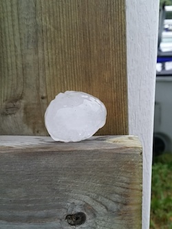
(PHOTOS: Damaging hail fell on Timmins and area late Monday afternoon. TimminsToday.com/Mike Young)


