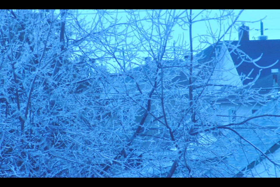
Temperatures that dropped just below the freezing mark Sunday evening and continued into mid-day Monday turned Timmins into glistening wonder land of glazed trees, shrubbery, hydro wires and car windows.
Though the sight was a marvel for the eyes, the slippery conditions were deemed unsafe for school bus operations, and most school bus services, but not all were cancelled for the early morning pick up of students, who had to find other transportation means to get to school.
For list of school bus route cancellations for Monday March 27 click here: School Bus Cancellations for Northeastern Ontario
Most schools in the Northeast were open and only a few schools in more remote areas actually closed.
Beginning Sunday evening, around the supper hour, as temperatures dipped from the plus temperatures that made for a thoroughly enjoyable day, Timmins and surrounding area where inundated with light freezing rain.
The light freezing ended around 9 a.m., according to Environment Canada, and light freezing drizzle fell from that point until noon on Monday.
Light rain fell from noon to about 3 p.m. and then turned to light drizzle at 5 p.m. before stopping altogether.
All in all, it turned out to be a rather blue Monday. If the frozen streets weren’t enough of a misery for the morning, as temperatures rose in the afternoon, the melting ice and light rain turned the streets into a splashfest where distracted pedestrians got soaked.
Those previously walkable sidewalks turned into impassable pools of water.
Yet there was something very pretty about the glazed city of Timmins with frosted trees, poles, fire hydrants and parking meters.
And if having to deal with the weather it self wasn’t enough, trying to understand what the weather forecasters were talking about presented another host of problems as people tried to go about their business.
It started with light freezing rain that turned to freezing drizzle, then drizzle and light rain.
Even the announcer over at CBC Morning north was caught at one point differentiating between freezing rain and wet rain. Wet rain? Isn’t rain supposed to be wet? I guess not if it is freezing rain.
For the record, here are definitions that may make the daily weather lingo a little clearer in the future.
These definitions are taking from Environment Canada Weather and Meteorology Glossary
Environment Canada's Weather Glossary
Drizzle is defined as precipitation from stratus clouds, made up of fine water droplets, which appear to float.
Drizzle is not to be confused with mist, which Environment Canada defines as very small to microscopic-sized water droplets, that are suspended in the atmosphere, usually in association with precipitation, and causing obstruction to visibility from one-half (1/2) to five (5) nautical miles, inclusive.
Freezing drizzle is defined as, drizzle that freezes on impact to form a coating of clear ice (glaze) on the ground and on exposed objects.
Freezing rain is defined as, rain that freezes on impact to form a coating of clear ice (glaze) on the ground and on exposed objects.
If you listen to American forecasts, you may sometimes come across the term sleet. Canada does not use the term, which many take to mean as synonymous to freezing rain. Sleet is a form of precipitation consisting of ice pellets, often mixed with rain or snow.
Of course Environment Canada does define ice pellets as, tiny particles of ice that are formed when supercooled raindrops freeze before reaching the ground.
While ice pellets are, tiny and fall in cold weather, hail is larger, and falls in association with thunderstorms in spring, summer and fall.
Environment Canada defines hail as precipitation in the form of lumps of ice mainly associated with thunderstorms. Hail ranges in size from that of a small pea to the size of cherries, but has been observed as large as grapefruit. Hail in Canada occurs most frequently during the summer when thunderstorm activity is at its peak.
The good news is that for the next several days Environment Canada forecasts mainly sunny skies with temperatures ranging from plus two on Tuesday to plus 8 on Saturday. Some rain or light snow is called for on Saturday, the first day of April, but according to Environment Canada their forecast is no April Fools.
Night time temperatures will range from minus 3 to minus 11 mainly clear nights.


