There are lots of different rocks on the back roads.
Rocks are the foundation of life on Earth and without the way geology works, we would not be here.
Not just that though rocks are good to look at, especially the sparkly ones. Piles of rocks are interesting, and so are the pebbles we pick up, the rocks we skip and those we can’t lift.
The following won’t make the ‘101 Incredible Rock Formations Around The World’ but in the scheme and scale of things, amazingly, these three examples are within kilometres of each other near Ignace, northwest of Thunder Bay on Highway 17.
Dolmen mystery stones
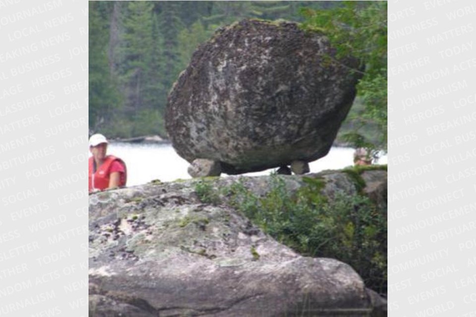
There are dolmen stones in northern Ontario. A dolmen usually consists of three or more upright stones supporting a larger stone. It remains unclear when, why, and by whom the earliest dolmens were made.
The oldest known dolmens are in Western Europe, where they were set in place around 7000 years ago. Archaeologists still do not know who erected these dolmens, which makes it difficult to know why they did it. They are generally all regarded as tombs or burial chambers, despite the absence of clear evidence for this. Human remains, sometimes accompanied by artifacts, have been found in or close to them, which could be scientifically dated, but it has been impossible to prove that these archaeological remains date from the time when the stones were original. Most date from the early Neolithic period (4000 to 3000 BC). Dolmens were usually covered with earth or smaller stones to form a barrow, though in many cases that covering has weathered away, leaving only the stone "skeleton" of the burial mound intact.
In North America many people have attached different theories and legends to the dolmen – some of them are: these are burial markers, it’s a Viking marker; a way to communicate as route way markers or it is a glacier erratic.
The late Dennis Smyk was the recipient of the Queen’s Jubilee Medal, the owner and editor of the Driftwood newspaper in Ignace and a licenced avocational archaeologist. He identified and registered hundreds of archaeological sites throughout northwestern Ontario during his long-time residency. At the time he brought me to the three rock sites all in one day with only a little effort, two very short walks and a short paddle.
He said he could not “write up the one we visited because dolmens are not recognized as archaeological sites (“Unless one finds other stuff [Indigenous artifacts or pictographs] he said).
“I have a difficult time accepting that the glaciers deposited so many large stones on top of two or more smaller ones.” Most prescribe to the erratic theory. A glacial erratic is a piece of rock that differs from the size and type of rock native to the area in which it rests these are found just about everywhere in northern Ontario. When you visit several dolmen sites your mind starts to behave like the proverbial pendulum. Is it by luck the melting ice occurred in such a way the larger boulder became supported by the smaller one? There are other dolmen stones in northern Ontario.
West of Ignace on Hwy. 17 drive for 24 km to the Doreen Lake Rd., heading south to southeast for 24 km. Turn ESE or left onto Moosehide Rd. Drive 2.5 km and you will cross a small bridge and another 2.0 km and you will come to an access with lakes on both sides of the road. Take the lake (referred to as Devil’s Gap Lake) on the south or right side. Paddle south to the east shore (1 km) of the first lake (no name). Portage to the second no-name lake and paddle to the SE bay and the dolmen is close to the water’s edge on the SE shore WGS 84 15 U 581575 5455282 or N49° 14’41.5” W91° 52’ 45.1” (also a day trip). Topo maps 52 G5 Ignace and 52 G4 White Otter Lake will help. (There is a great set of pictographs on Devil’s Gap Lake - part of the Turtle River Provincial Park canoe route- south of the gap on the west shore.)
Erratic behaviour
Humans sometimes exhibit erratic behaviour but even rocks can do so.
Boulders of a particular rock type which may be many tonnes in weight may be found sitting on a different type of bedrock; sometimes they are perched prominently in open areas. For the most part, they tend to be rounded. The surface is often fine-grained indicating grooves and scratches, remnants of the movement of the ice sheets and the constant scoring by neighbouring boulders. After the ice melted the boulders remained distributed in a random way.
Most parts of Northern Ontario have been glaciated that is, ice sheets once enveloped the landscape. Glacial striae (you can see these scratch patterns on the bedrock) and glacially oriented features, such as drumlins and eskers, indicate that the general direction of ice movement was towards the southwest. So as a result most areas have erratic boulders.
Just north of Sandbar Lake Provincial Park, 15 kilometres north of Ignace the landscape is dominated by large room-size boulders some of the largest in Canada. Visitors walking among these behemoths cannot but be overwhelmed by them.
Dennis said, “The Ignace boulder field came to light following forestry operations. In 2004, the boulders stood out above the cut over. Five years later, rapidly growing jack pine began to hide them from nearby access roads. People interested in the promotion of the area engaged Sandbar Ontario Rangers to undertake brushing to open up the areas around the boulders and create trails between them.
He explained what a geomorphologist told the locals about their origin. “These boulders were angular chunks of fractured granite that were removed from the bedrock surface by advancing ice about 10, 000 years ago. This was usually accomplished by freeze-and-thaw processes in which water (often under very high pressure at the base of the ice) makes its way into fractures, freezes, expands as ice and wedges the fractured blocks apart. The blocks were eventually plucked out and became entrained (frozen) in the ice.
Their size and uniformity (i.e. all granite) suggest that they were derived locally (likely within 5 km) and deposited fairly close to where they originated in bedrock. After the ice retreated, meltwater would flow between the boulders and winnow out all but the largest boulders. The finer material would be deposited farther downstream. The transport in ice and contact with meltwater has smoothed some of the sharp, angular edges that these blocks would have had initially.”
The size of these boulders and their proximity to the Trans Canada Highway means that there is a great deal of interest by boulderers, aficionados of the sport of bouldering, a style of rock climbing undertaken without a rope and normally limited to very short climbs so that a fall will not result in serious injury. It is typically practiced on large boulders or artificial man-made boulders. “The Ignace Boulder Field has been described as “the best bouldering in Canada between the Niagara Glen and the Rockies!” He said, “Visitors will enjoy the experience of seeing the boulders - or climbing them – and can top up their visit by feasting on the namesake blueberries.” The landscape is starting to fill in but you can find these 15 km north of Ignace on Highway 599 (Savant Lake), pass the Park entrance and drive 4.3 km and turn at WGS 84 15 U E607201 N5484213 or N49° 30.064’ W91° 31.166’ (note you are on the 49th N parallel of latitude); drive 0.7 km NNW and then turn WSW and drive less than 0.5 km, the boulders are in sight (north side) scattered amongst the jack pine. These are enormous. You can see the extensive field as large white dots on Google Earth. While in the area go back to Sandbar Provincial Park, walk the sand beach to the lookout.
Dynamite oven
A little bushwhacking ensues.
Suddenly it is there, a mound of rocks shaped like a small igloo. This is different.
The round pile is about 3 m in diameter and 2 m high and there is a small doorway too small for a person to crawl through. It looks like one of those wood-fired ovens.
Near the structure are boulders that have been quarried, blasted and seemingly sorted by size. It is known there were two railway quarries in operation. The dynamite was stored in these cool, dry structures. These date back more than a century. Dennis says, “Quarrying of the large blocks appears to be accomplished with black powder in widely spaced drill holes.”
It is located between Highway 17 North to the CPR railway line about 100 m apart. Park about 50 m east of the humongous boulder (south side) and 2 km west of Ignace, just before the beginning of the passing lane sign. Walk north about 50 m towards the railway line. If you reach the railway you will see the two-mile marker sign, it is about 30 m west; then go south towards the highway is the rock pile. To minimize the walk through the bush the GPS will lead you there, it’s a neat find; WGS 84 15 U E594712 N5476665 or N49° 26.116’ W91° 41.620’.
Bonus
Last week we looked at rocks in Wawa, while you are in the Ignace area consider two pictograph sites that are worth the effort. One is very close to the dolmen stone the other is an extensive collection on Mameigwess Lake, just west of town. It is another opportunity to learn about Indigenous culture particularly their relationship with the land. See the map for all the back roads’ assets.


